Smart City Planning for the West Dongba of Beijing
Beijing Municipal Institute of City Planning & Design develops multiple rail lines and two subway stations for the district that will spark an overall transformation and rebirth of the project area, as well as promote various modes of green and active transportation, including bicycles. However, the institute knew proper planning for the project was critical. The team used CUBE to analyze travel volume, distribution, and modes of transportation to and from the district. Using the information to optimize the design, the organization improved travel efficiency by 15% and significantly reduced the use of carbon-emitting vehicles while easing navigation through the city and improving health.
Dam operator Yuba Water ensures safety and resilience of the New Bullards Bar Dam
The New Bullards Bar Dam provides flood control, 340 megawatts of clean energy, and a reliable supply of water for residents and the ecosystem. Over 50 years after its construction, extreme weather events have become more frequent and intense, increasing the risk to its structural integrity. To improve inspections and obtain the level of detail that dam operator Yuba Water Agency needed, they combined drone surveys and automated sensors with Bentley applications. As a result, Yuba Water can immediately assess the dam during extreme weather events and after earthquakes to prevent disasters.
Geoinfo Services improving water availability and quality for the city of Ayodhya
The ancient city of Ayodhya is one of the seven holiest cities in India for Hindus, yet it lacks regular access to clean water due to a gravity-based water system with significant leaks, resulting on nonrevenue water approaching 50%, and pipes that took too long to fill. To reduce the amount of energy that a replacement water system would require, as well as its corresponding 347 tons of annual carbon emissions, Geoinfo Services applied Bentley’s Water Digital Twin technology to establish a monitoring system that provides real-time information about the state of the system.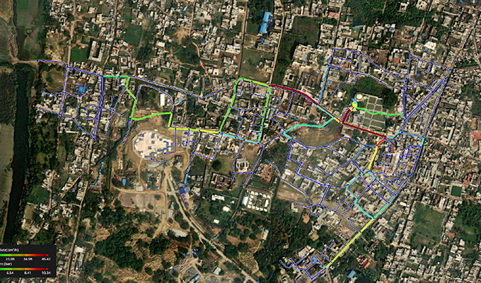
Kenya Geological Survey establishes a nationwide map of the country’s natural resources
To keep their country resilient, overcome climate change challenges, as well as keep up with a growing population, the government of Kenya initiated a nationwide survey to create a detailed inventory of the country’s natural resources including critical aspects for sustainable development, such as forest cover, water bodies, geothermal energy potential, and rare earth elements. Establishing a nationwide map efficiently drives geothermal energy production, alleviates water access issues, and scales up responsible mining, which is particularly critical for energy transition pathways and access to clean, affordable water.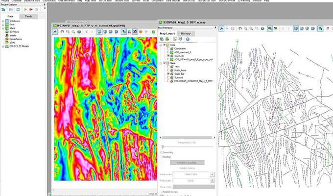
Port Authority of New South Wales: A Case Study in Digital Transformation
Managing numerous seaports along the southeastern coast of Australia, Port Authority of New South Wales realized that a living digital twin of all its facilities could improve their understanding of the current state of all assets and the environment, helping them fine-tune operations and undertake new projects with a high level of confidence. Visualization of the project reduces the need for site visits, and digital management empowers a variety of projects that benefit the local economy. The digital twin of the seaport areas is improving safety, livelihood, and ocean ecosystem health, and are actively driving the sustainable development of the blue economy.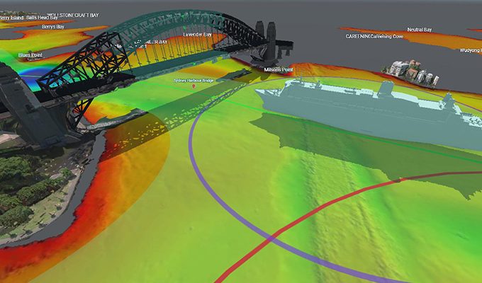
Contact Energy expanding renewable energy sources with Tauhara Geothermal power station
The 174-megawatt Tauhara Geothermal power station uses geothermal production and injection wells to connect the geothermal reservoirs with the station itself. To efficiently target the reservoirs, which are between 1.7 kilometers to 3 kilometers below the surface, Contact Energy used applications from Seequent, the Bentley subsurface company, to fully visualize geological data in a 3D space. With a full understanding of the area, Contact Energy drilled multiple wells from the same location, resulting in a smaller environmental footprint. Now operational, the power station eliminates over 500,000 tons of carbon emissions per year and generates 12% of New Zealand’s electricity.
Project Control Cubed addressing water scarcity and sustainable agriculture with EchoWater Project
As one of the largest water treatment projects in the world, EchoWater will upgrade infrastructure to treat 135 million gallons of wastewater per day, providing a reliable supply of treated water, improving water quality, and alleviating ecological problems. Applying Bentley’s digital twin technology in a connected visual environment, the Project Control Cubed team anticipated and mitigated potential obstacles and system shutdowns, while staying aware of costs and construction schedules. Project Control Cubed completed the USD 400 million project under budget, and the state of California is using that money on the Harvest Water program to boost agriculture in the state’s Central Valley and enhance the variety of food produced.
Kalpataru Projects International minimizing carbon footprint with Cameroon Power Transmission Project
Spanning several regions of Cameroon where 55% of the population live in poverty, grid connectivity is limited, and the power supply is unreliable, this project will extend the country’s electricity network with two 225-kilovolt, single-circuit transmission lines and supporting substations. To overcome the challenges presented by swamps and dense forests prone to inclement weather, Kalpataru Projects International created a full digital twin of the project to monitor material use and fuel consumption and minimize its carbon footprint. By eliminating diesel power generation in the region, the organization reduced carbon emissions equivalent to 450 megatons per month while promoting industrialization, economic growth, and improved quality of life.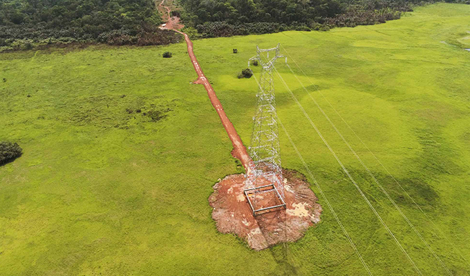
ARQ and Partners Consulting Engineers ensuring flood protection with Jufainah (B6) Dam
The city center area of Qurum, a suburb of Muscat, is experiencing a growing number of flash floods. To protect the area, Oman’s Ministry of Agriculture, Fisheries Wealth, and Water Resources initiated a flood protection plan consisting of six dams, with ARQ and Partners providing technical support for the Jufainah B6 Dam. By undertaking sophisticated geotechnical analysis and minimizing the negative impacts of the various foundation properties, the team chose and refined an optimal design, which greatly reduced the amount of stress placed on the dam’s plastic concrete core while lowering costs by 30% and construction time by two months. With a stable design, the dam will help protect the 700,000 people of Qurum and 120,000 people in Al Amerat from 500-year floods while improving the local aquifer and enhancing local agriculture.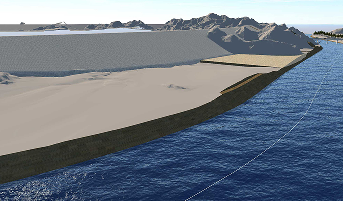
Arcadis’ South Dock Bridge reducing embodied carbon emissions
The new South Dock pedestrian bridge in London’s iconic Canary Wharf will improve urban connectivity and encourage active sustainable transport, as well as lower carbon emissions and improve air quality. Designed as a bascule bridge with an overall span of 75 meters and a lifting span of 35 meters, the project presents technical and architectural challenges, which include a striking aesthetic design as well as counterweighted bascule spans and bridge operating equipment within the north abutment, both of which will reduce energy use. Through digital planning and design, the team reduced embodied carbon and provided a basis for construction monitoring and proactive maintenance, minimizing environmental impact beyond simply providing accessible, low-carbon transportation.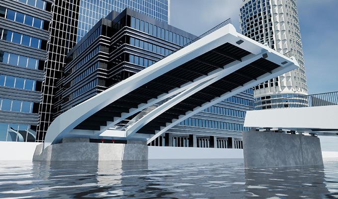
Geothermal Institute’s modeling of Paris basin area ensuring sustainable zero-carbon heating source
The geothermal reservoirs underneath Paris are already providing low-energy heating to more than 250,000 homes and the Paris-Orly Airport. To responsibly manage this valuable resource, the Geothermal Institute of the University of Auckland, in collaboration with geothermal consulting company Geofluid, sought to improve its geotechnical understanding of the reservoirs. They used Leapfrog Geothermal to build a geological model that includes a numerical representation of the geothermal production in the area. The visualization gives all stakeholders an intuitive grasp of geothermal use, ensuring a sustainable zero-carbon heating source for much of the city.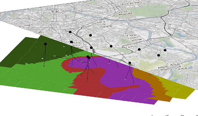
M/s Egis India Consulting Engineers creating future-proofing stormwater drainage system in Srinagar City
Rapid growth presented significant problems for Srinagar. Lacking a well-defined sewer and storm water drainage system, Srinagar experienced major damage from a 2014 flood that impeded development of the area. The city contracted M/s Egis India Consulting Engineers to create a 767-square-kilometer stormwater drainage system that is separate from the sewage system. The designed drainage system not only minimizes the impact of floods on the city, it solves the persistent problem of sewage discharging into bodies of water, improving the health of residents and the natural environment.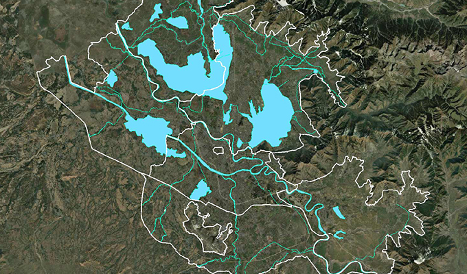
State Grid Tianjin Electric Power Survey, Design & Consulting to provide carbon-free solar energy to industrial parks in Baiguan Town
State Grid Tianjin Electric Power Survey, Design & Consulting was tasked with constructing a 330-kilowatt solar array, data center stations, electric vehicle charging stations, and 5G base stations. To design the complex, multidiscipline concept, they used Bentley applications to establish a single development platform and create 3D models of all assets. The digital designs improved efficiency, prevented errors, reduced the environmental footprint, and shortened construction time. Solar power from the array has eliminated 2,700 tons of carbon emissions per year.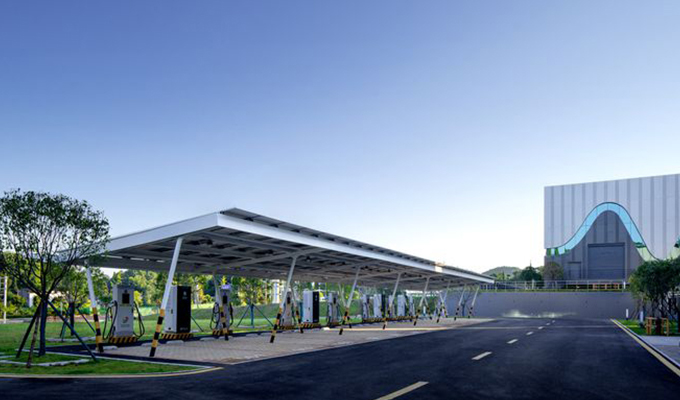
Italferr supporting Italy’s renewable energy project with digital twin technology
In a major effort to boost the amount carbon-free, renewable energy in Italy to 40% of total generation, Gruppo Ferrovie dello Stato Italiane is installing solar farms that will generate a combined 2 gigawatts in 26 different locations throughout the country. Each facility requires numerous assets in addition to the solar panels, including structural support, monitoring systems, security systems, roads, and fences. Managing such a sprawling, complex project requires tight data management. Italferr created digital twins of each site, helping all stakeholders to understand the design intent and communicate with each other. The process improved productivity, saved work hours, and reduced the need for on-site travel, helping to increase Italy’s solar generation by 10 percent and continue the transition from more carbon-intensive power generation.
IDOM reaching a new level of quality and sustainability in the Rail Baltica Project
The largest single infrastructure project in the Baltics, Rail Baltica is an 870-kilometer international passenger and freight railway corridor linking Lithuania, Estonia, and Latvia. It will save EUR billions in annual freight transport costs and EUR 7.1 billion in climate change costs, as well as reduce carbon emissions, atmospheric pollutants, and noise to their lowest possible levels. To deliver the project, IDOM established a connected data environment and used Bentley’s open applications for collaborative 3D modeling and clash detection. The teams achieved a 90% accuracy rate transitioning from design to construction and minimizing change orders. In addition to saving 5.3 million passenger hours per year, the rail project will dramatically reduce climate change costs, reduce air pollution by 18.3%, and lower noise by 4.5%.
ADComms ensuring low-carbon rail network through Deep Tube Upgrade Program
Though the residents of London rely on the London Underground rail system, some of its lines need refurbishment to keep traffic flowing. As part of a rail system update, a one-person-operation system of a connected series of cameras allows rail drivers to see the whole train and the platform edge from monitors within the cab. Bentley applications helped reduce the project’s environmental impact by reducing the need for travel and site visits. By giving rail drivers a clear view of the train and its surroundings, ADComms is improving safety and efficiency, increasing capacity, reducing congestion, and enhancing passenger experience in the London Underground, ensuring that the rail network remains a low-carbon backbone of the city’s transportation.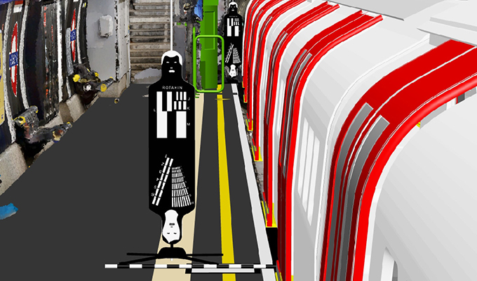
Vattenfall’s modeling of dynamic seabed conditions helps decarbonizing offshore windfarm construction
As the world transitions to cleaner energy, offshore wind farms have become an attractive investment. However, sea floors can vary widely in depth and composition, making a clear understanding of geological conditions critical to ensuring stable long-term operations. As one of the first steps to developing the Norfolk Boreas Offshore Windfarm off the coast of the United Kingdom, Vattenfall needed to incorporate the terrain characteristics into their design, but previous applications did not provide the level of detail needed. With Oasis montaj, design teams quickly processed data into a terrain model, creating an accurate representation of the site. The information will help them lower the amount of steel needed for construction, eliminate the risk of structural failure, and ensure the production of zero-carbon energy.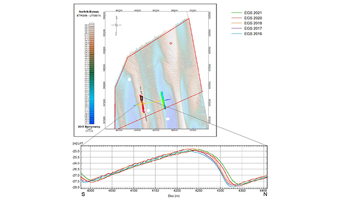
Geoambiente develops hydrogeological model resulting in cleaner aquifers and safer drinking water
In the late 1970s, a sprawling, 116,000-square-meter industrial complex in Brazil began manufacturing agricultural machinery and vehicles. Decades of machining, tooling, painting, and washing vehicle parts, in addition to other industrial processes, polluted the area with organochlorine and hydrocarbon contaminants. Though these plumes are affecting local aquifers used for obtaining drinking water, the full scope of contamination has never been fully understood. Geoambiente used Leapfrog to develop a hydrogeological model of the entire area, allowing them to estimate with a high degree of certainty the contaminants’ sources and their total masses, as well as mapping entrapment and migration zones. With the knowledge gained from the model, the company placed absorptive barriers in areas with the highest concentration of contaminants and significantly reduced contaminant levels.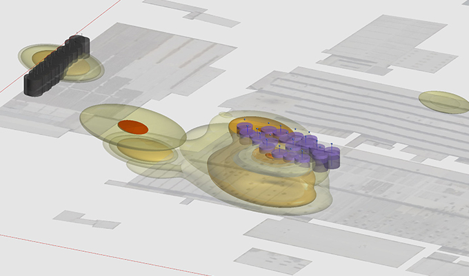
SIDRI Kubuqi 2000MW Photovoltaic Desertification Control Project (Section I) for clean energy production
Deserts are particularly well-suited for solar power, as the areas have abundant sunlight and less competition for land compared to more populated and agriculturally active regions. Located in the Kubuqi Desert in Inner Mongolia, the Kubuqi 2,000-megawatt photovoltaic desertification control project aims to provide clean energy through photovoltaic power generation. Upon completion, it is expected to provide power to more than 1 million households and greatly reduce annual emissions of various pollutants. Upon completion, the project will reduce the use of coal by 706,600 tons per year, which will eliminate 1.93 million tons of carbon emissions, 371 tons of sulfur dioxide emissions, and 415 tons of nitrogen oxide emissions.
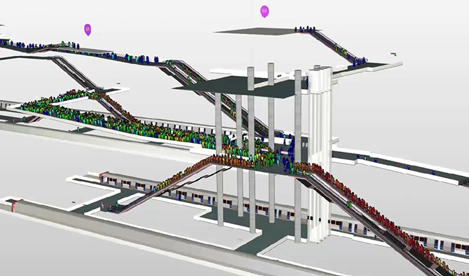
Metro Istanbul 3D passenger simulation allows for future-proofing sustainable transportation
From 2000 to 2022, the population of Istanbul grew by 50%. The increase has caused significant traffic problems and the city needed to efficiently expand its public transportation system to improve the traveler experience, ensuring citizens are transported from the surface to the platform in a short time, comfortably, and in a sustainable way. Metro Istanbul initiated the Seyrantepe - Alibeyköy pocket bus station metro project, which has three stations across 6.9 kilometers and can serve 70,000 passengers per hour. Using LEGION, project planners simulated how passengers would use the stations and optimized their design to avoid bottlenecks and prepare evacuation scenarios during emergencies.